The Seventeen Sleeping Giants Above Bhutan
Listen.
At fourteen thousand feet in the eastern Himalayas, the air does not just thin out; it sharpens, carrying the metallic tang of crushed granite and the low, percussive groan of shifting ice that sounds like a freight train idling beneath your boots. Meanwhile, you can find related developments here: Why Obsessing Over Israel's Election Deadlock Misses The Real Geopolitical Shift.
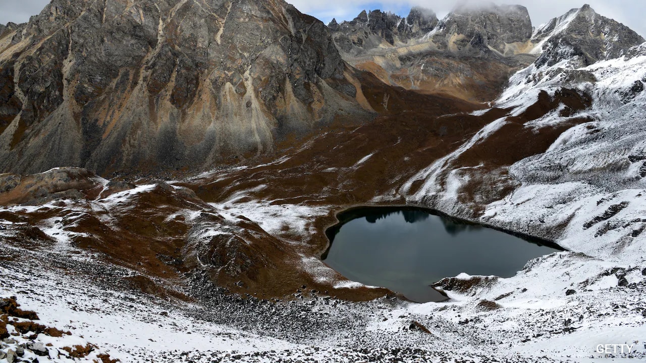
If you stand at the edge of Thorthormi Lake in northern Bhutan, you are looking at a mirror of turquoise water so bright it hurts the eyes, framed by jagged peaks that scrape the stratosphere. It looks like a postcard. It looks like sanctuary. Yet beneath that serene surface, millions of cubic meters of meltwater are pressing against a wall of loose rubble, sand, and dead ice—a natural dam held together by little more than frost and friction.
Across the Bhutanese Himalayas, there are 567 glacial lakes. Seventeen of them have been classified by glaciologists and Bhutan’s National Center for Hydrology and Meteorology as potentially dangerous. To explore the complete picture, we recommend the recent article by Al Jazeera.
Seventeen.
To a hydrologist sitting in an office in Thimphu, that number is a data point on a hazard map, a red triangle indicating a high risk of a Glacial Lake Outburst Flood, known in scientific shorthand as a GLOF. To a farmer planting red rice in the Punakha Valley eighty miles downstream, that number is an invisible weight suspended directly above his roof.
The Architecture of a Broken Dam
To understand why these seventeen lakes keep Bhutanese engineers awake at night, you have to stop thinking of a mountain lake as a bowl carved into solid bedrock.
Think instead of a bathtub made of wet sand, sitting at the top of a steep staircase.
As glaciers retreat—and in the eastern Himalayas, they are retreating at an accelerating, relentless pace—they leave behind deep depressions gouged into the earth. Meltwater fills these basins. Holding the water back is a terminal moraine: a ridge of unsorted rocks, gravel, and silt pushed forward by the glacier over centuries, cemented together by an internal core of permafrost.
For millennia, the cold kept that cement hard as concrete. Now, rising temperatures are thawing the ice core inside the rubble. The mortar is turning to mud.
Consider what happens next. A chunk of hanging ice—a serac the size of a ten-story building—calves off the retreating glacier face and plunges into the lake. Or an earthquake rattles the ridge. Or heavy monsoon rains swell the basin past its brim. A displacement wave surges across the water, overtopping the fragile moraine wall. Once water begins spilling over loose gravel, erosion does not happen gradually; it happens exponentially. The notch widens in minutes. The dam unzips.
What follows is not a flood in the way most of us understand the word. It is a hyper-concentrated debris flow—a churning, thirty-foot wall of black water, boulders the size of delivery trucks, uprooted pine trees, and pulverized rock moving down narrow V-shaped valleys at thirty miles per hour.
A Memory Written in Mud
Bhutan does not need a computer simulation to know what this looks like. The scar tissue is still visible along the Pho Chhu river.
Take a hypothetical composite of the families living in the Punakha Valley—let us call the father Dorji, a third-generation farmer whose fields sit on the fertile alluvial flats just below the confluence of the Pho Chhu and Mo Chhu rivers, near the towering white walls of the Punakha Dzong.
On the night of October 6, 1994, there was no storm in Punakha. The sky was clear. Yet miles upstream, at an elevation of over 14,500 feet, the moraine dam of Luggye Tsho gave way. Roughly 18 million cubic meters of water burst free.
In Dorji’s memory—and in the collective memory of the valley—the sound arrived before the water. It was a deep, sub-audible vibration that rattled the wooden shutters of the farmhouse, followed by a roar that drowned out the river’s normal rush. By dawn, the valley floor was unrecognizable. Twenty-one people were dead. Hundreds of acres of prime agricultural land were buried under six feet of gray, sterile boulders and glacial silt. Even the Punakha Dzong, the seventeenth-century fortress that serves as the spiritual and administrative heart of the region, suffered severe structural damage, saved from total destruction only by the angle of the river bend.
Luggye Tsho was just one lake. And in 1994, it was not even considered the most volatile one in the basin.
Right next to Luggye Tsho sits Thorthormi.
For years, glaciologists watched Thorthormi with quiet dread. Separated from the neighboring Rapstreng Lake by a rapidly thinning wall of unstable moraine, Thorthormi was swelling into a massive, interconnected reservoir. If Thorthormi breached and cascaded into Rapstreng below it, the resulting domino effect would unleash more than 50 million cubic meters of water—nearly three times the volume of the 1994 disaster.
The Men Who Dug a Mountain by Hand
When you read about climate adaptation in policy journals, it usually sounds sterile. You read about capacity building, hydrological modeling, and mitigation infrastructure.
In Lunana, one of the most remote inhabited regions on Earth—a place reachable only by an eight-day trek over high mountain passes where yaks carry everything that cannot fit on a human back—climate adaptation looked like three hundred men standing waist-deep in freezing water with pickaxes and crowbars.
Between 2009 and 2012, the Bhutanese government launched one of the most audacious high-altitude engineering projects ever attempted. You cannot fly heavy excavators to 14,500 feet; the thin air starves helicopter engines of lift. So Bhutan sent people.
Imagine the daily reality of that crew. Waking up in canvas tents coated in rime ice. Battling altitude sickness, blistering ultraviolet radiation, and sudden blizzards. Walking out onto the crumbling lip of Thorthormi’s moraine wall to manually widen and deepen an outlet channel, boulder by boulder, using wooden levers and bare muscle to lower the lake’s water level by five meters.
I have stood on high Himalayan moraines in October, when the wind cuts straight through three layers of wool and every breath feels like inhaling crushed glass. Just walking fifty yards uphill leaves your heart hammering against your ribs. Doing heavy excavation work there for months on end borders on the superhuman.
By the time the crews hiked down in 2012, they had drained roughly 17 million cubic meters of water from Thorthormi, buying the valleys below precious decades of breathing room. It was a triumph of grit over gravity.
Yet the mountains did not stop warming.
The Quiet Math of Vulnerability
Here is the uncomfortable truth that keeps climate scientists up at night: lowering one lake does not stop the glaciers from melting. It merely buys time while new lakes form and old ones expand.
Bhutan’s vulnerability is uniquely acute because of its geography. The country is essentially a staircase dropping from 24,000 feet down to 300 feet in less than a hundred miles. Almost all of Bhutan’s arable land, its major towns, its cultural heritage sites, and its economic lifeline sit tucked into the narrow river valleys directly beneath those seventeen high-risk lakes.
Consider the economic arteries at stake. Bhutan is one of the few carbon-negative countries in the world, largely because of its vast forest cover and its massive investments in run-of-the-river hydropower. Hydropower exports to India generate roughly a quarter of the nation’s gross domestic product and fund its free healthcare and education systems.
Unlike massive reservoir dams, run-of-the-river hydro plants sit directly in the path of the mountain rivers, diverting water through tunnels to spin turbines. They have almost no buffer against a sudden wall of boulders and sediment. A single major GLOF in the Chamkhar Chhu, Mangde Chhu, or Punatsangchhu basins could wipe out billions of dollars in infrastructure in forty-five minutes, plunging the national budget into crisis and severing highways that take years to rebuild across sheer cliff faces.
And what about the people who live along the riverbanks?
When I speak with travelers who have trekked through Bumthang or stayed in Punakha, they often ask why villagers do not simply move higher up the slopes. The answer is written into the topography. Above the valley floor, the slopes tilt at forty-five to sixty degrees. You cannot plow a sixty-degree cliff. You cannot easily pipe water to a ridge three thousand feet above the river. For centuries, survival in the Himalayas meant hugging the water. Now, the water has turned unpredictable.
Listening for the Siren
If you travel through the Punakha or Chamkhar valleys today, you will notice tall metal poles topped with solar panels and horned loudspeakers standing near bridges, schools, and monasteries.
This is the physical manifestation of Bhutan’s early warning system—a network of automated water-level sensors and glacial lake monitoring stations wired via satellite and cellular relays to a central control room in Thimphu, staffed twenty-four hours a day.
The logic is brutally simple. You cannot stop a moraine from collapsing once it goes. You can only steal minutes from the flood.
Depending on which lake breaches, communities downstream have anywhere from twenty minutes to three hours between the moment the sensors detect a sudden drop in lake level—or a spike in river flow—and the moment the debris wall hits the first village.
Think about what twenty minutes means in real life.
Imagine a schoolteacher in a riverside village—let us call her Pema—who hears the piercing wail of the siren cut across a quiet Tuesday morning. She has twenty-four second-graders in her classroom. She does not have time to call parents. She does not have time to grab textbooks or lock doors. She has time to line those children up, hold the hands of the slowest runners, and sprint up the designated concrete evacuation stairs carved into the hillside until they reach the green painted line marking the safe elevation zone.
In communities along the Punatsangchhu and Mangde Chhu basins, these drills are no longer theoretical exercises. Villagers know which footpath leads to high ground. Monks know which sacred relics sit in the lowest vaults of the dzongs. Storekeepers keep emergency bags packed near the door.
Yet even the best early warning system carries an inherent fragility. High-altitude sensors get battered by lightning, buried under six feet of snow, or severed by rockfalls. Maintaining telemetry equipment at 15,000 feet requires teams to trek for days every summer just to replace batteries and recalibrate gauges before the monsoon clouds roll in. There is always a margin of terror—a lingering question of whether the signal will get through on the exact night it is needed most.
The Weight of Unfinished Business
We tend to talk about climate change in the future tense, as a looming deadline set for 2050 or 2100.
In the high valleys of Bhutan, climate change is measured in centimeters per week at the edge of a moraine dam. It is an immediate, physical equation playing out above the heads of people who contributed virtually nothing to the greenhouse gases warming their peaks.
Bhutan absorbs more carbon than it emits. Its constitution mandates that at least sixty percent of the country remain under forest cover in perpetuity. By every metric of environmental stewardship, the people living beneath those seventeen glacial lakes have done everything right. They kept their forests intact. They rejected mass tourism in favor of low-impact preservation. They measured progress not by industrial output, but by Gross National Happiness.
And yet, because atmospheric physics knows nothing of moral fairness, the ice above them continues to melt.
Scientists at the National Center for Hydrology and Meteorology continue to hike into the high basins every summer, lowering bathymetric sonar boats into freezing turquoise water to map the changing depths of lakes like Raphstreng, Thorthormi, and Lemthang Tsho. They install new sensors. They reinforce riverbanks with wire-mesh gabions filled with stone. They train new generations of village responders.
They are doing everything humanly possible to manage a threat that originates thousands of miles away, in the smokestacks and tailpipes of the industrialized world.
Up at fourteen thousand feet, as evening falls and the temperature drops below freezing, the cracking sound of the glacier slows down. The turquoise water turns slate gray, then black, reflecting the first cold stars piercing the Himalayan sky. Beneath the surface, the pressure against the ancient rubble remains constant, patient, and absolute—waiting to see whether the mountain holds until morning.