Finding your way around central Ohio isn't just about knowing where High Street is or how to avoid the 315 split at rush hour. It’s about the numbers. If you've lived here long enough, you know that a zip code map of Columbus Ohio tells a much deeper story than just where your mail goes. It's a patchwork of historic brick roads in 43206, the high-octane energy of the Arena District in 43215, and the sprawling, quiet suburbs of 43081.
Honestly, the way these codes are laid out is kinda fascinating once you dig in. Most people think they're just random, but there’s a formulaic system dating back to 1963. Back then, the USPS wanted to speed things up, so they took the old two-digit zone codes and baked them right into the five-digit numbers we use today.
Take the Ohio State University, for example. Ever wonder why their code is 43210? It’s not just a cool countdown. The "4" stands for the region (Ohio, Kentucky, Michigan, and Indiana). The "32" is specifically for Columbus. And that "10"? That was the old zone code for the university post office.
Decoding the Zip Code Map of Columbus Ohio
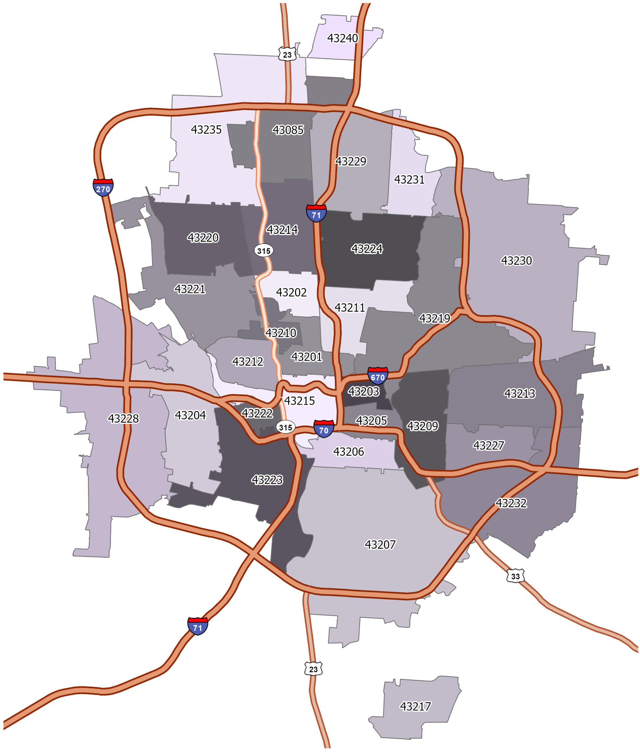
If you look at a full map today, you'll see about 43 specific zip codes within the city limits, but the greater metro area easily pushes that number over 60. It’s a lot. And it’s changing. With the "Zone In" initiative happening right now in 2026, the city is aggressively rezoning nearly 40% of its land to handle the population boom. This doesn't usually change the five-digit zip, but it drastically changes the "vibe" and density of those areas.
The Downtown Core and the Short North
The heartbeat is 43215. This is where you find the skyscrapers, the statehouse, and the Scioto Mile. But here’s a tip: it actually shares space with the southern half of the Short North. If you move further north toward Victorian Village or Italian Village, you'll suddenly find yourself in 43201. It’s a subtle shift on a map, but the housing prices and parking situations change instantly.
The Affluence Hubs
If you’re looking for where the wealth is concentrated on the map, your eyes should drift toward the northeast and northwest.
- 43054 (New Albany): Frequently ranked as the wealthiest zip in the region. It’s got that manicured, white-fence look.
- 43065 (Powell): Another heavy hitter in Delaware County.
- 43221 (Upper Arlington): Old money, beautiful stone houses, and very strict lawn maintenance vibes.
- 43021 (Galena): This one surprises people, but it actually holds some of the highest median household incomes in the entire metro area.
Why the Map Borders Are Often Blurred
Boundaries are weird here. You’ll find people who say they live in Clintonville, but their mail says 43214. Others in the same neighborhood might be in 43202. The city of Columbus has this "octopus" shape because of how it annexed land over the decades. You could be in a Columbus zip code but pay taxes to a different school district, or live in a suburb like Blacklick (43004) that feels like its own world but is technically part of the city's sprawl.
Neighborhoods like Franklinton (43222) are seeing massive shifts. Ten years ago, the map showed it as a purely industrial and low-income pocket. Today, it’s a tech and arts hub. When you look at the zip code map of Columbus Ohio, you're seeing a living document of where the money is moving.
Surprising Density in 43229 and 43232
Not every code is about high-rises or mansions. Areas like 43229 (Northland) and 43232 (Eastland) are huge residential engines. They offer more affordable housing than the trendy 43206 (German Village), but they come with different logistical challenges. Traffic on Morse Road or Hamilton Road in these zones is no joke.
Practical Steps for Using This Data
If you’re moving, starting a business, or just curious, don't just look at a static image. Maps evolve.
- Check the School Districts: Zip codes and school boundaries do NOT always align. Use the Franklin County Auditor’s site to verify which district a specific address actually falls into.
- Verify Zoning Changes: Since the 2026 "Zone In" updates are live, check the city's interactive GIS maps to see if that quiet street in 43204 is about to get a four-story apartment complex next door.
- Analyze Income Trends: If you're a business owner, 43082 (Westerville) and 43026 (Hilliard) are currently prime spots for mid-to-high-tier retail because of the stable family demographics.
- Factor in the "Cbus Octopus": Remember that your zip code determines who picks up your trash and which police department shows up. A map will show you the lines, but the 311 service portal is your best friend for actual city services.
The layout of Columbus is more than just a grid. It’s a series of concentric circles and jagged lines that tell you exactly where the city has been and where it’s headed. Whether you're in the 43210 campus bubble or the quiet cul-de-sacs of 43123 (Grove City), the numbers matter.
Grab a digital GIS map from the Franklin County portal for the most up-to-date boundary lines, especially as new developments in the "Silicon Heartland" continue to push the boundaries of what we consider "Columbus."