Ever looked at a map of the continent and wondered why everyone calls this place the "heart" of Southern Africa? If you're hunting for Zimbabwe on Africa map, you'll find it tucked away, landlocked, and looking a bit like a rough-edged diamond wedged between some of the biggest names on the continent. It doesn't have a beach. No crashing Atlantic waves or Indian Ocean turquoise. Honestly, it doesn't need them.
Zimbabwe is basically the "connective tissue" of the region.
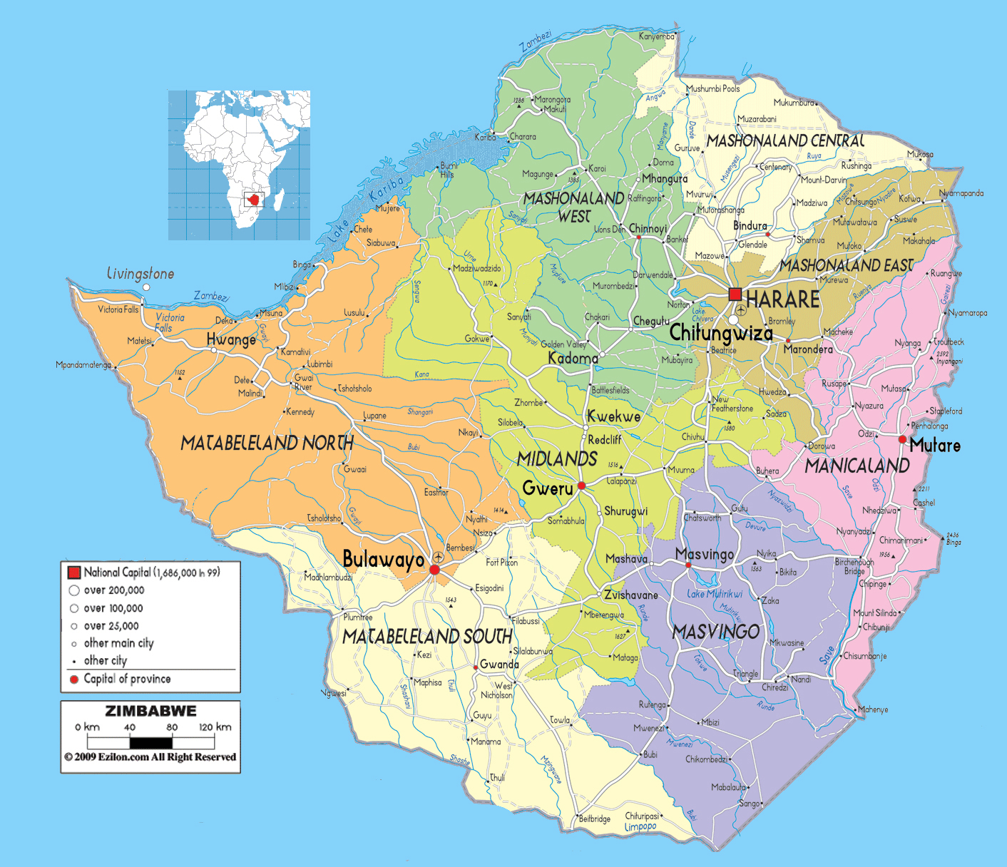
It sits right there at approximately $20^\circ S$ and $30^\circ E$. To the north, you've got the Zambezi River acting as a massive, watery border with Zambia. To the south, the Limpopo River separates it from South Africa. It's like the country is held in place by these two giant river veins. To the east, the jagged mountains of Mozambique tower over the border, and to the west, the flat, dry expanse of Botswana stretches out.
Why the Location of Zimbabwe on Africa Map Changes Everything
People often think being landlocked is a disadvantage. In some ways, yeah, shipping stuff is a headache. But geographically? It’s a jackpot. Because Zimbabwe sits on a high plateau—often called the "Highveld"—it doesn't get that suffocating, sticky heat you find in other tropical spots. Most of the country is over 1,000 meters above sea level.
That height makes the weather almost perfect. It’s subtropical, not "I-can't-breathe" tropical.
The Neighbors Next Door
When you're staring at the map, notice how Zimbabwe acts as a transit hub. If you're driving from Cape Town to Lusaka or Lubumbashi, you’re almost certainly passing through.
- South Africa (South): The big economic brother. The Beitbridge border post is one of the busiest inland ports in the whole of Africa.
- Zambia (North): Home of the shared glory that is Victoria Falls. They share the water, the electricity from Kariba Dam, and a lot of history.
- Mozambique (East): This is Zimbabwe’s gateway to the sea. The "Beira Corridor" is the lifeline for fuel and imports coming in from the Indian Ocean.
- Botswana (West/Southwest): A long, relatively flat border where the Kalahari sands start to creep in.
The Landmarks You Can See From Space
If you zoom in on a satellite view of Zimbabwe on Africa map, a few things jump out immediately.
First, there’s Lake Kariba. It looks like a giant blue slug on the northern border. It’s actually the world’s largest man-made lake by volume. When they built the dam in the 1950s, they created an inland sea that’s now a massive source of hydro-power and tiger fishing.
Then there’s the Eastern Highlands. If the rest of the country is golden savanna, this part is emerald green. It’s a 300-kilometer stretch of peaks, including Mount Nyangani, the highest point at 2,592 meters. It feels more like the Scottish Highlands than "typical" Africa. Coffee and tea plantations thrive here because the mountains trap the moisture coming off the Indian Ocean.
The "Smoke That Thunders"
You can't talk about the map without mentioning Victoria Falls (Mosi-oa-Tunya). It’s right there on the northwest tip. It’s not just a waterfall; it’s a 1.7-kilometer wide curtain of falling water. During the peak flow around April, the spray rises so high you can see it from miles away. It’s the literal corner where Zimbabwe and Zambia meet, and it’s basically the tourism magnet of the entire region.
The Strategic Reality of Being Center-Stage
Being in the middle of the map means Zimbabwe is a "bridge" state. Geopolitically, this has always been its blessing and its curse. In the 13th century, the Kingdom of Great Zimbabwe (you can still see the massive stone ruins near Masvingo) sat at the center of trade routes connecting gold mines in the interior to Swahili traders on the coast.
Today, that hasn't changed much. The "North-South Corridor" is a fancy term for the main road and rail veins that move copper from Zambia and the DRC down to the ports in Durban. If Zimbabwe's borders close, half of Southern Africa's trade starts to choke.
Does it have a desert?
Not really. While it gets dry in the south—near the Tuli Block and the Lowveld—it’s not the Sahara. It’s mostly Miombo and Mopane woodlands. Baobab trees, those upside-down looking giants, are everywhere in the hotter, lower regions. They are like the anchors of the landscape.
Making Sense of the Map for Your Trip
If you're planning to visit, don't just look at the dots. Understand the elevations.
- Harare (The Capital): Sits high up in the northeast. It’s cool, breezy, and full of purple Jacaranda trees in October.
- Bulawayo: The second city, sitting in the southwest. It’s the gateway to the Matobo Hills, where the granite boulders look like they were stacked by giants.
- The National Parks: Hwange is on the western edge, bordering Botswana. Mana Pools is in the far north on the Zambezi floodplains.
Honestly, the best way to "see" Zimbabwe on a map is to look at the river systems. Everything flows toward the Zambezi or the Limpopo. It’s a land defined by its water, even if it doesn't have an ocean.
To get the most out of this geography, you should look into the regional cross-border passes. If you're visiting Victoria Falls, many travelers grab a "KAZA Univisa," which lets you hop between the Zimbabwe and Zambia sides of the map without paying for two separate full visas. It's a small logistical detail that makes the "middle-of-the-map" location way more accessible.