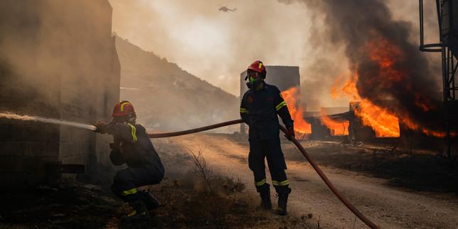
Effective wildfire containment relies on rapid spatial intervention, fuel management continuity, and real-time resource allocation. When an ignition event occurs in the urban-wildland interface southeast of Athens, the primary metric of success is not merely the cessation of active flame fronts, but the minimization of structural vulnerability, ecological degradation, and economic disruption. The successful circumscription of a localized fire in this corridor demonstrates tactical firefighting efficacy, yet it exposes systemic weaknesses in regional prevention architectures, topography-driven wind vectors, and municipal evacuation bottlenecks.
The Operational Anatomy of Mediterranean Wildfires
The topography of the southeastern Attica peninsula creates unique meteorological and physical challenges for emergency response agencies. Steep terrain, fragmented vegetation patterns dominated by pine forests and dry scrub, and proximity to densely populated residential corridors dictate a high-velocity fire propagation model.
[Ignition Source] -> [Topographic Acceleration] -> [Urban-Wildland Interface] -> [Resource Saturation]
When a fire ignites under conditions of low relative humidity and sustained regional winds, such as the Etesian winds characteristic of the Aegean summer, the rate of spread outpaces standard ground response times.
The containment of the southeast Athens fire required the immediate deployment of aerial assets combined with localized ground crew deployment. Aerial intervention serves a specific operational function: cooling active flame fronts and creating tactical delays via water and retardant drops. However, aerial suppression is fundamentally limited by wind velocity, visibility restrictions, and turnaround times for refilling operations. Ground crews must simultaneously execute direct attack strategies on flank sectors and indirect containment strategies by constructing fuel breaks ahead of the vector.
The primary operational variable governing this containment event was the transition from free-spreading propagation to perimeter constriction. This transition is dictated by three distinct variables:
- Fuel Continuity Break: The interruption of combustible biomass either naturally via rocky outcrops or artificially via pre-existing firebreaks and cleared residential perimeters.
- Meteorological Shift: A localized drop in wind speed or shift in wind direction that reduces forward momentum and allows tactical containment lines to hold.
- Asset Density: The concentration of heavy fire engines, mobile water tankers, and specialized forest commando units at the head of the fire rather than dispersed across multiple secondary flare-ups.
Systemic Vulnerabilities in Urban-Wildland Boundaries
The southeastern periphery of Athens represents a classic urban-wildland interface failure point. Urban sprawl has progressively encroached upon forested hillsides, creating a fragmented landscape where residential structures intermix directly with highly volatile vegetative fuel loads. This spatial configuration alters the thermodynamic profile of wildfires. Homes act as secondary fuel sources, while narrow access roads impede the bidirectional flow of emergency apparatus and evacuating civilian traffic.
The containment success of the recent incident masks a deeper structural inefficiency in regional risk management. Reactive suppression strategies consume disproportionate financial and operational capital compared to proactive mitigation. Proactive mitigation requires rigorous enforcement of defensible space regulations around residential properties, continuous clearing of underbrush, and the installation of localized water infrastructure independent of municipal supply grids that frequently fail during major grid power outages caused by fire damage.
Furthermore, evacuation logistics remain a critical point of failure. Single-access road networks in hillside suburbs create immediate gridlock when evacuation orders are issued simultaneously. This restricts the mobility of incoming firefighting units, creating a dangerous operational paradox where civilian evacuation routes and tactical deployment routes occupy the same spatial corridor.
The Economic and Environmental Cost Function
Quantifying the impact of wildfires in the Attica region requires evaluating both immediate suppression expenditures and long-term ecological degradation. The economic cost function of an ignition event comprises direct asset loss, infrastructure repair, suppression resource deployment costs, and subsequent economic dampening in tourism and regional commerce.
$$\text{Total Cost} = C_{\text{suppression}} + C_{\text{infrastructure}} + C_{\text{ecological}} + C_{\text{economic}}$$
In this equation, $C_{\text{suppression}}$ represents the hourly operational cost of aerial fleets and personnel overtime. $C_{\text{ecological}}$ accounts for the loss of mature pine ecosystems, which increases soil erosion susceptibility and drastically elevates flash flood risks during subsequent autumn precipitation events. The denudation of vegetative cover alters the hydrological response of local watersheds, transforming minor rainfall into destructive mudflows that threaten downstream urban settlements.
The containment of the fire prevents the escalation of $C_{\text{infrastructure}}$ and $C_{\text{ecological}}$, yet the reliance on post-ignition containment ensures that baseline expenditures remain recurrently high every fire season.
Resource Allocation Optimization Under Uncertainty
Emergency response agencies in Greece operate under severe resource constraints relative to the geographical expanse of high-risk territory. When multiple ignition events occur concurrently during peak meteorological risk windows, resource prioritization becomes an exercise in triage.
Decision-making algorithms must weigh structural asset value against ecological preservation and topographical containment feasibility. Directing heavy air assets to a localized fire in southeast Athens requires pulling resources away from larger, more remote fronts in rural regions or vice versa. This spatial competition for assets necessitates a transition from static positioning to predictive dynamic prepositioning.
Predictive prepositioning utilizes high-resolution meteorological forecasting, fuel moisture content telemetry, and historical ignition density mapping to place mobile intervention units in high-probability risk sectors before ignition occurs. Reducing response latency from twenty minutes to five minutes alters the entire trajectory of fire growth, keeping the fire within the initial attack capacity threshold and avoiding the requirement for massive multi-agency mobilizations.
Strategic Operational Mandate
Regional authorities must systematically decouple civil protection budgets from reactive suppression dominance and redirect capital toward pre-ignition landscape management.
- Enforce mandatory perimeter clearing standards for all residential structures within fifty meters of forest boundaries, backed by municipal auditing and strict penalties for non-compliance.
- Redesign secondary egress routes in high-risk hillside settlements to segregate civilian evacuation traffic from emergency apparatus access lanes.
- Deploy automated, solar-powered water misting and suppression systems along critical urban-wildland buffer zones to suppress initial crown fire ignition before manual ground or aerial units can arrive.
- Establish decentralized water reservoirs equipped with independent diesel generators in elevated suburban zones to maintain firefighting water pressure during regional electrical grid failures.