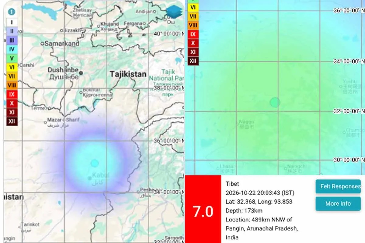
Reporting a major earthquake in Tibet followed by a moderate tremor in Afghanistan as a simple chain reaction mistakes geographic proximity for direct physical causation. Across the Alpine-Himalayan collision belt, a magnitude 7.0 rupture releases roughly 28,000 times more seismic energy than a magnitude 4.1 event, yet a magnitude 4.1 tremor occurs routinely across active fault systems even without a preceding major shock. Understanding what connects or separates these events requires separating shared tectonic loading from static stress transfer, auditing time-of-day vulnerability such as morning shaking, and evaluating how emergency operations respond when two crisis zones sit thousands of kilometers apart.
Deconstructing the Competitor Narrative
Headlines that pair a magnitude 7.0 earthquake in Tibet with a magnitude 4.1 earthquake in Afghanistan during morning hours serve a clear newsroom function: they capture rapid updates from a wide geographic band and signal urgency to readers scanning breaking alerts. That format also carries structural flaws that distort risk perception.
- Conflating sequence with causation: Placing two tremors in one headline implies that the Tibet rupture pushed Afghanistan over an edge, even when distance and magnitude math argue against direct triggering.
- Treating magnitude as a linear scale: Moving from 4.1 to 7.0 is not a modest step up; moment magnitude is logarithmic, so energy scales by roughly a factor of 31.6 per full unit.
- Omitting physical constraints: A summary that stops at magnitudes and morning timing leaves out focal depth, fault mechanics, local site amplification, and population exposure.
- Flattening cross-border complexity: Tibet and Afghanistan share the broad Indo-Eurasian convergence zone, but they occupy distinct fault regimes, governance environments, and infrastructure baselines.
The first analytical gap in conventional breaking coverage is treating chronological order as a causal pipeline. Two events separated by roughly 2,000 to 2,500 kilometers—depending on exact epicenters—rarely represent one fault tearing all the way from the Tibetan Plateau into the Hindu Kush or Pamir ranges. Instead, both regions sit inside the same continental collision engine, where the northward push of the Indian plate loads multiple fault systems over decades and centuries.
The second limitation involves scale distortion. When a reader sees "7.0" and "4.1" side by side in a short alert, the brain naturally compares them as nearby points on a ruler. In seismology, a magnitude 4.1 event is a light-to-moderate tremor that people near the epicenter can feel, often causing minor rattling or alarm, whereas a magnitude 7.0 event is a major earthquake capable of widespread structural damage, ground rupture, landslides, and regional infrastructure disruption.
The Three Pillars of Continental Seismic Coupling
To analyze paired tremors across High Asia rigorously, treat any two earthquakes in the broader collision zone through three distinct physical and operational pillars: Stress Regime Architecture, Wave and Trigger Physics, and Exposure and Response Asymmetry.
Stress Regime Architecture
The Indian plate drives north into Eurasia at roughly 40 to 50 millimeters per year, forcing crustal thickening, uplift, and strike-slip or thrust motion across a vast belt stretching from Myanmar and Tibet through the Himalayas into Pakistan and Afghanistan. Within this broad convergence zone, deformation is partitioned across sub-blocks rather than carried by a single continuous crack.
On and around the Tibetan Plateau, crustal deformation involves thrust faulting along the Himalayan front alongside extensive strike-slip and extensional fault systems inside the plateau interior. Further west, toward the Pamirs and Hindu Kush, compression tightens into intense mountain-building and deep crustal or intermediate-depth seismicity. Because each fault segment accumulates elastic strain at its own rate and locks along asperities of different sizes, a large rupture on one fault does not automatically synchronize every neighboring segment.
Wave and Trigger Physics
When a magnitude 7.0 earthquake strikes, seismic waves radiate outward across the globe, and the static stress field in the crust shifts near the rupture zone. Whether that event triggers a magnitude 4.1 tremor far away depends on physical distance, wave amplitudes, and how close a distant fault already sits to failure.
Known facts establish that seismic waves from major earthquakes pass through distant regions and can occasionally nudge critically stressed faults—a phenomenon studied under dynamic triggering—while static stress changes decay rapidly with distance from the fault plane. By contrast, claiming that a specific magnitude 4.1 shock in Afghanistan was directly caused by a magnitude 7.0 shock in Tibet is an educated hypothesis at best unless detailed waveform, timing, and Coulomb stress modeling support it, and in many cases a magnitude 4.1 event is simply background or independent tectonic activity occurring on the same day.
Exposure and Response Asymmetry
Even if two earthquakes happen within hours of each other, their operational consequences diverge sharply. A major shock in a high-altitude, sparsely populated, or rugged part of Tibet presents challenges of extreme elevation, cold weather, long road distances, and communications limits. Meanwhile, a magnitude 4.1 tremor in Afghanistan—even when felt in the morning—carries a very different baseline risk profile than a major destructive shock, yet it still lands in a region where older unreinforced masonry and fragile lifelines make any ground shaking a source of anxiety and local hazard.
Morning timing adds a human dimension that breaking alerts mention in passing without unpacking. Early-morning shaking catches residents indoors, often asleep or starting daily routines, which can increase injury risk if heavy items fall or if people rush outside into streets lined with unstable walls or power lines. At the same time, daylight soon follows in many morning scenarios, aiding visual assessment compared with pitch-black night conditions, though cold temperatures can still complicate sheltering if people evacuate damaged buildings.
The Cost Function of Multi-Shock Ambiguity
When headlines link a major earthquake and a smaller tremor across borders without clarifying mechanics, three downstream costs emerge for public safety, media credibility, and crisis management.
- Misallocated public attention: Readers may fixate on the smaller distant tremor or assume a cascading wave of disasters is sweeping across every neighboring country, distracting from actual hazards near the primary rupture.
- False certainty in risk forecasting: Treating two events as a predictable chain creates the illusion that analysts know where the next shock will hit, even though earthquakes cannot be reliably predicted by exact time, place, and magnitude.
- Delayed operational triage: Emergency teams and humanitarian planners need clear separation between confirmed high-severity impacts near the magnitude 7.0 epicenter and lower-magnitude background or secondary activity elsewhere so resources match verified need.
This creates a bottleneck in early crisis hours when raw seismic feeds arrive faster than verified ground reports. Automated agency alerts often post preliminary magnitudes, depths, and locations within minutes, while confirmed casualty and damage figures take hours or days to emerge from remote terrain. Mixing unverified assumptions of linkage into early reporting compounds confusion just when precision matters most.
Operational Protocol for Reading Multi-Quake Alerts
Anyone tracking seismic alerts—whether a risk analyst, logistics coordinator, or informed reader—can evaluate paired earthquake reports systematically using four steps.
- Separate event records by epicenter and magnitude: Treat the magnitude 7.0 event and the magnitude 4.1 event as distinct seismic sources first, checking exact coordinates, origin times, and depth estimates rather than merging them into one narrative.
- Convert magnitude differences into realistic expectations: Recognize that a magnitude 7.0 shock represents a major energy release with regional damage potential, whereas a magnitude 4.1 shock is a minor-to-light tremor whose primary impact is often felt shaking rather than broad structural collapse, unless depth is very shallow and exposure is unusually vulnerable.
- Check local hazard multipliers: Look past the number on the scale to ask about focal depth, distance to populated valleys, landslide susceptibility on steep slopes, and building construction quality.
- Track verified aftershocks separately from distant tremors: Near the magnitude 7.0 fault, aftershocks are expected and can themselves be strong enough to damage weakened structures; a magnitude 4.1 event thousands of kilometers away belongs to a different local context unless seismologists identify a specific connection.
Consider a practical example of how this logic works in operations. Suppose a supply chain manager tracks routes across High Asia when a morning alert flags a magnitude 7.0 earthquake in Tibet and a magnitude 4.1 tremor in Afghanistan. Rushing to halt unrelated western corridors based on the 4.1 tremor alone wastes time and capacity, whereas auditing mountain roads, slopes, and telecom links near the 7.0 zone—while staying alert to local aftershocks and landslides—aligns action with physical severity.
Limits of Current Seismic Assessment
Rigorous analysis also requires stating where current science and operational intelligence hit hard boundaries. Seismologists can map major faults, measure long-term plate motion, and estimate regional hazard probabilities over decades, yet no instrument can guarantee when a locked fault will slip or how large a rupture will grow before it starts.
Early magnitude and depth estimates are frequently revised as more stations process waveforms, and remote mountainous regions often experience reporting lags after major events. Furthermore, distinguishing a dynamically triggered small earthquake from a coincidental background tremor on a tectonically active plate boundary remains difficult in real time. Treating uncertainty as a known constraint—rather than masking it behind dramatic headlines—keeps risk decisions grounded.
For organizations, emergency planners, and analysts monitoring seismic activity across High Asia, the decisive strategic move is to build alert workflows around source-specific severity and local exposure rather than geographic proximity or headline pairing: verify the primary magnitude 7.0 rupture zone and its immediate aftershock and landslide risks first, evaluate any secondary or distant tremors against local vulnerability and depth before acting, and maintain clear separation between confirmed damage reports and early automated seismic parameters.


