Ranking rivers by depth is a vanity project for geographers who prefer spreadsheets over the chaotic reality of fluid dynamics. Most "top ten" lists you find online are echo chambers of recycled data from the 1990s, written by people who wouldn't know a sounding line from a fishing rod. They treat the world’s great waterways like static swimming pools when, in reality, a river is a shifting, violent, and breathing entity that defies precise measurement.
If you think the Congo River is "220 meters deep" because a textbook told you so, you’re missing the point of how water actually works. If you enjoyed this article, you should look at: this related article.
The Myth of the "Deepest" Point
When we talk about the Congo or the Yangtze, we are talking about canyons submerged under thousands of tons of sediment-heavy water. Most rankings claim the Congo is the deepest at roughly 220 to 250 meters. But here is the problem: river depth is not a fixed coordinate. It is a snapshot in time.
Rivers are high-energy systems. They scour their own beds and then fill them back up with silt. A spot that measures 200 meters during a flood might be 180 meters six months later because of sediment deposition. Relying on a single "maximum depth" figure is like trying to measure the height of a wave in the middle of a hurricane. It is technically possible to get a number, but that number is irrelevant by the time you publish it. For another perspective on this development, refer to the recent update from AFAR.
Furthermore, the technology used to measure these depths—multibeam echo sounders—is only as good as the person interpreting the data. In the narrow, turbulent gorges of the lower Congo, the "depth" is often just a series of plunge pools created by massive underwater cataracts. We aren't measuring a floor; we are measuring a jagged, vertical labyrinth.
The Congo River is an Anomaly, Not a Metric
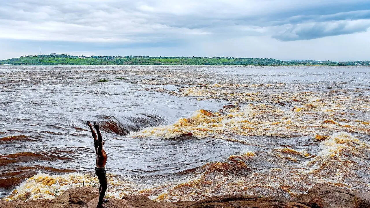
Everyone starts their list with the Congo. They point to the "Lower Congo Rapids" and marvel at the 220-meter abyss. What they fail to mention is that this depth isn't a sign of a "great" river; it’s a sign of a geological bottleneck.
The Congo is unique because it flows through a narrow canyon where the water is forced through a gap less than half a mile wide. The sheer velocity of the water—moving at over 30 miles per hour in some spots—acts like a hydraulic drill, carving deep holes into the bedrock.
Why the Amazon is Actually Deeper (In Spirit)
If you want to talk about true hydraulic power, the Amazon laughs at the Congo’s 220-meter pits. While the Amazon’s average depth hovers around 20 to 50 meters, its volume is incomparable.
- Amazon Flow Rate: 209,000 cubic meters per second.
- Congo Flow Rate: 41,000 cubic meters per second.
The Amazon doesn't need to be 200 meters deep because it is miles wide. Depth is often a symptom of a river being trapped. The Amazon is a river that has conquered its landscape; the Congo is a river still fighting its way out of a mountain range. Ranking the Congo higher just because it’s "deeper" is like saying a narrow straw is better than a firehose because the water inside the straw is taller.
The Yangtze and the Industrial Lie
The Yangtze often takes the silver medal in these lists, cited at around 200 meters in the Three Gorges area. But here is the industry secret: those depths are now artificial.
Since the completion of the Three Gorges Dam, the Yangtze is no longer a natural river system in the way the Congo is. It is a series of managed reservoirs. When you "measure" the depth of the Yangtze today, you are measuring the height of a man-made lake. The sediment is piling up behind the dam at an alarming rate, meaning the "200-meter" depth is shrinking every single day.
If you’re a traveler looking for the "deepest river," you aren’t looking for nature; you’re looking at a plumbing project. Most articles ignore this because "10 Deepest Rivers" sounds better than "10 Rivers with the Most Silt Management Issues."
The Danube and the European Obsession with Precision
The Danube is frequently cited as the deepest river in Europe, with a maximum depth of about 178 meters at the Iron Gates. This is the "lazy consensus" at its finest.
The Iron Gates is a gorge between Serbia and Romania. Similar to the Congo, this depth is found in a very specific, narrow stretch. For 99% of its length, the Danube is relatively shallow. If you fell off a boat in the Danube, you’d be much more likely to hit your head on a sandbar than to sink 100 meters.
We obsess over these extreme outliers because they make for good clickbait, but they tell us nothing about the river's character. A river's depth at its "maximum point" is a statistical anomaly, not a defining characteristic.
Stop Asking "How Deep?" and Start Asking "How Fast?"
If you actually want to understand the power of these systems, depth is the wrong variable. You should be looking at discharge and velocity.
| River | Max Depth (Estimated) | Avg Discharge (m³/s) | The Real Story |
|---|---|---|---|
| Congo | 220m | 41,000 | A vertical, turbulent death trap. |
| Yangtze | 200m | 30,100 | A managed industrial canal. |
| Danube | 178m | 6,500 | A shallow stream with one deep hole. |
| Zambezi | 116m | 3,400 | Defined by its falls, not its floor. |
| Amazon | 100m | 209,000 | The undisputed king of volume. |
When you look at the numbers this way, the "rankings" collapse. The Danube has no business being mentioned in the same breath as the Amazon, regardless of a single deep hole in a Serbian gorge.
The Danger of Trusting Sonar Data
As someone who has looked at bathymetric maps for years, I can tell you that "depth" is often an educated guess. In high-sediment rivers like the Mississippi or the Mekong, the water is so thick with silt that sonar pulses can reflect off "false bottoms." These are layers of suspended sediment that are too thick for the pulse to penetrate but aren't actually the riverbed.
In the 1980s, we thought certain parts of the Mississippi were significantly deeper than they actually are because we were measuring the top of a "mud plume."
The Mississippi: The Depth Myth Closer to Home
The Mississippi is usually listed at 61 meters (200 feet) near Algiers Point in New Orleans. This is the deepest point of the entire 2,300-mile river.
Think about that for a second. We rank the Mississippi among the "deepest in the world" based on a single bend in the river that represents 0.0001% of its total length. The rest of the river is so shallow that the Army Corps of Engineers has to dredge it constantly just to keep barges from scraping the bottom.
Ranking the Mississippi as a "deep river" is a lie. It is a wide, shallow river with a few deep potholes caused by man-made levees forcing the water to scour the bottom at sharp turns.
The Impact of Seasonality
In the Mekong, the river level can fluctuate by over 10 meters between the dry season and the monsoon. If you measure the Mekong in October, it’s a giant. If you measure it in April, it’s a collection of puddles and streams.
Any ranking that doesn't provide a date and a GPS coordinate for its "depth" is useless. The "status quo" in travel writing is to ignore this complexity because it doesn't fit into a neat "Top 10" format. They want you to believe the earth is a static map. It isn't. It's a vibrating, eroding mess.
Why You Should Care
Why does this matter? Because when we misrepresent the physical reality of our planet for the sake of a "listicle," we lose our understanding of ecology.
Deep-water species in the Congo, like the blind cichlids that live at the bottom of those 200-meter trenches, are being threatened by changes in flow, not just "depth." If we only care about the number, we miss the mechanics of the habitat. These fish have evolved to survive intense pressure and darkness—conditions more similar to the ocean floor than a typical river.
The Final Verdict on Depth
If you are a traveler or a student of geography, stop looking for the "deepest" anything.
Depth is a boring, one-dimensional metric used by people who want to simplify the world. Instead, look at the geomorphology. Look at how the river interacts with the rock. Look at the turbidity.
The "Deepest Rivers" lists are fundamentally flawed because they equate a measurement with an identity. The Congo isn't interesting because it’s 220 meters deep. It’s interesting because it’s a high-velocity hydraulic engine that creates isolated evolutionary pockets. The Amazon isn't "shallow" just because it doesn't have a 200-meter hole; it’s a continental-scale flooding system that dictates the climate of an entire hemisphere.
Throw away your rankings. The most important parts of a river are the ones you can’t measure with a string and a weight.
Go to the Congo. Watch the water boil at the surface because of the sheer pressure coming from 200 meters below. Realize that no chart can capture that violence.
The river doesn't care about your ranking. It’s too busy moving mountains.