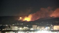
Nearly 90,000 residents across northwest Reno faced mandatory evacuation orders or urgent warnings as the human-caused Hawk Fire tore through the Peavine Peak foothills, surging toward the edge of the University of Nevada campus. With zero containment, erratic wind gusts, and a path that literally jumped over active fire engines, the blaze exposed deep structural vulnerabilities in how rapidly expanding high-desert communities manage emergency mass displacement.
The fire started on a Saturday as a seemingly minor footprint in the Humboldt–Toiyabe National Forest, but dry fuels and shifting atmospheric channels transformed it overnight into a multi-thousand-acre monster. Approximately 42,000 residents received strict "GO NOW" orders, while another 45,000 were placed under immediate warning zones. Yet the statistical scale of the evacuation masks a far more critical operational breakdown: the friction between public panic, highway bottlenecks, and the chaotic dissemination of real-time threat data.
The Anatomy of an Unpredictable Run
Wildfires in the Great Basin do not behave like timber fires in the Pacific Northwest or brush fires in Southern California. They move through cheatgrass and dry sagebrush communities where wind velocities can double in minutes. When the Hawk Fire hit the ridges above Somersett and the northern valleys, it did not spread in a predictable front. It spotted ahead of itself, throwing embers hundreds of yards across canyons.
Washoe County Sheriff Darin Balaam noted that the flames moved fast enough to outpace emergency units, jumping over deployed fire trucks and trapping crews between hot spots. This dynamic created an information vacuum. Residents trying to track the blaze relied on commercial mapping applications and emergency portals that lagged hours behind the physical fire front. For families like the Kieffers, who discovered their home was gone only after fleeing via social media updates, the lag time between ground reality and official notification highlights a persistent failure in municipal warning infrastructure.
Infrastructure Strain and the Urban Interface
Reno is expanding upward and outward into the rugged foothills. This urban-wildland interface creates an impossible math problem for emergency planners. When thousands of vehicles funnel down narrow arteries like U.S. Route 395—portions of which had to be closed due to active flames and zero visibility—the system seizes.
Nearly 10,000 customers lost power, taking down local traffic signals and standard home internet routers. Without power, residents lost access to local broadcast updates unless they were tuned to analog emergency radio.
- The Shelter Dilemma: Evacuation centers such as the Reno-Sparks Convention Center filled up quickly, but standard protocols barred pets from entering the primary human shelters. Displaced families faced an impossible choice: abandon animals to designated secondary shelters miles away or refuse to evacuate on time.
- Institutional Vulnerabilities: Two regional hospitals were forced to move patients, and law enforcement had to draft contingency plans for the county detention facility situated perilously close to the outer warning zones.
The Human Error Factor
Authorities confirmed that the Hawk Fire was human-caused, though investigations into whether it stemmed from negligence, equipment failure, or an abandoned campfire remain open. In a region already exhausted by repeated emergency declarations—including multiple fires earlier in the month that displaced over 13,000 people—the margin for error has vanished.
Governor Joe Lombardo mobilized the Nevada National Guard, deploying helicopter crews and dozens of troops to secure abandoned neighborhoods against looting. But boots on the ground and air tankers dropping retardant are reactive measures. They are bandages applied after the structural flaws of wildland-adjacent zoning have already been exposed.
As climate patterns prolong the traditional fire season across the American West, towns built on the edge of the sagebrush sea are learning a harsh lesson. Evacuation maps drawn on paper cannot keep pace with winds that change direction in a heartbeat, leaving tens of thousands of lives hanging on the edge of an unpredictable ridge line.