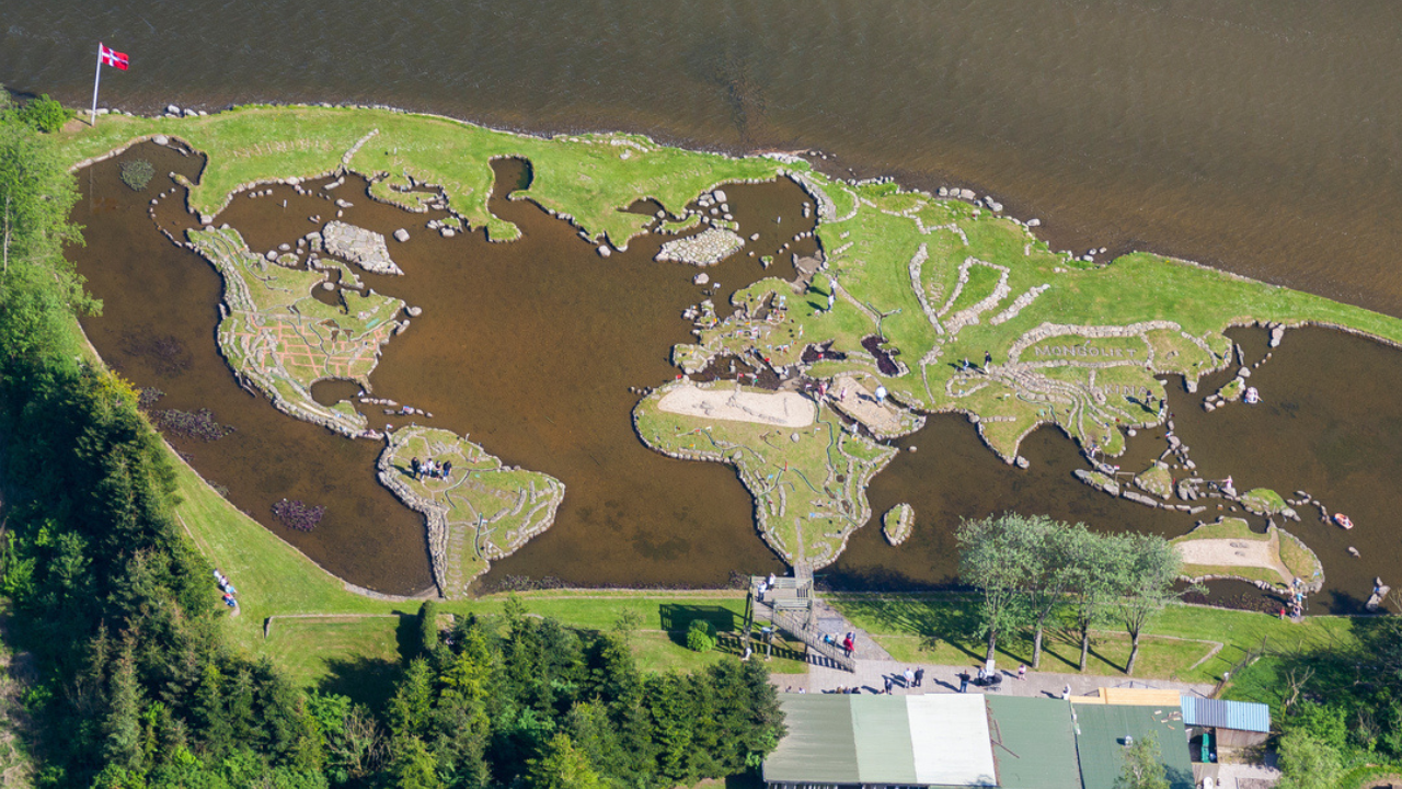
Søren Poulsen spent two decades moving rocks by hand to build the entire world at his feet. Located on the shores of Lake Klejtrup in Viborg, Denmark, Verdenskortet—literally translated as "The World Map"—is an astonishingly accurate, miniature representation of global geography scaled down to a single, walkable peninsula. Built entirely between 1944 and 1969, this massive stone-and-soil cartographic achievement attracts tens of thousands of visitors annually, serving as a testament to individual obsession and manual engineering before the era of heavy machinery or satellite mapping.
Most casual travel reporting treats Verdenskortet as a quirky, roadside novelty. It is far more than that. It represents a monumental feat of solo civil engineering, a masterclass in vernacular geography, and a profound psychological study of what happens when a person spends the later half of their life quite literally reshaping the earth.
The Genesis of an Obsession
Søren Poulsen was not a surveyor, a cartographer, or an engineer. He was a Danish-American immigrant who returned to his native soil after spending years working in the United States, primarily in Washington State. He was a fruit grower, a man accustomed to working with the land, understanding soil composition, and wrestling with the elements. When he returned to Denmark, he inherited the family farm near Lake Klejtrup.
The land was difficult. It was marshy, waterlogged, and largely unsuitable for intensive agriculture. Most farmers would have viewed the boggy edges of the lake as a liability. Poulsen, however, found an unusual stone.
In 1943, while working on the drainage of the surrounding meadows, Poulsen discovered a large stone that bore a striking resemblance to the shape of Jutland, the Danish peninsula. That single stone sparked an idea that would consume the remaining 25 years of his life. He decided he would not just farm the land; he would recreate the globe upon it.
He began the work in earnest in 1944, right in the midst of the German occupation of Denmark. While the world outside was fracturing along brutal geopolitical lines, Poulsen quietly began gathering stones to assemble a peaceful, unified version of it on his waterfront property.
Engineering the World Without Machinery
To understand the scale of Poulsen’s achievement, one must understand the physical constraints of his operation. He did not use excavators. He did not use cranes. His primary tools were a wheelbarrow, a hand-operated winch, a spirit level, and a custom-built wooden sled that he used to drag massive boulders across the ice during the harsh Danish winters.
The scale of Verdenskortet is roughly 11 centimeters to 11 kilometers. One meter on the map represents roughly 100 kilometers in reality. Achieving accuracy at this scale required a meticulous understanding of proportion.
Poulsen used simple, classic surveying techniques. He studied standard atlases, projected the coordinates onto his plot of land, and laid out the coastlines with small markers.
The Winter Strategy
The real breakthrough in construction happened when the lake froze. Denmark’s winters in the mid-20th century were consistently cold enough to create thick layers of ice across Lake Klejtrup. Poulsen used this to his logistical advantage.
- He would locate large, heavy boulders scattered across the surrounding fields during the spring and summer.
- He would transport these stones to the edge of the lake.
- When the ice froze solid, he dragged the boulders out onto the frozen surface, positioning them precisely where his grid indicated a coastline, a mountain range, or an island should be.
- When the spring thaw arrived, the ice melted, and the boulders dropped directly into the shallow lake bed, forming the permanent, underwater foundation for his continents.
He filled the spaces between the stone borders with thousands of wheelbarrows of dirt, sod, and clay, packing the earth tightly to withstand the constant erosion of the lake water. He planted grass to stabilize the soil, creating distinct green masses that accurately mirrored the shapes of the Americas, Eurasia, Africa, and Australia.
The Geopolitical Precision of a Self-Taught Cartographer
Walk across the site today, and the accuracy is jarring. Poulsen did not just approximate the shapes of the continents; he labored over the minor details.
The contours of the Mediterranean, the sharp protrusion of the Horn of Africa, and the fragmented islands of the Canadian Arctic are all distinctly recognizable. He even went so far as to include major mountain ranges, using smaller, jagged stones to represent the Rockies and the Andes. Red bricks were placed to mark the locations of major cities and capitals.
The map reflects the world as it was understood in the mid-20th century. Because the map is dynamic—surrounded by the actual water of the lake—it functions as a living geographic ecosystem. The miniature oceans are filled with the same water that supports local fish and bird populations.
There are minor concessions to reality, of course. Some smaller island nations are slightly oversized so that they do not wash away under the ripple of the lake's waves. The Equator is clearly marked with a yellow line, allowing visitors to comprehend the sheer scale of the projection they are traversing.
The Financial and Physical Toll
This was not a hobby funded by wealth. Poulsen poured his meager resources into the project. He lived frugally, dedicating every spare krone to the acquisition of soil and the maintenance of his tools.
The physical toll on a single individual doing this work into his 70s and 80s was immense. Moving stones weighing several hundred pounds with nothing but simple leverage and muscle memory is grueling work. Poulsen became a local fixture, an eccentric silhouette against the lake, constantly pushing a wheelbarrow, constantly adjusting the position of a rock by a few centimeters to satisfy his desire for accuracy.
By the late 1940s, the sheer scale of his creation began attracting curious onlookers. Neighbors came first, then people from neighboring towns, and eventually tourists from across Denmark. Poulsen realized that his private obsession could help fund its own completion. He began charging a small admission fee, which he immediately reinvested into buying more materials for the map.
Beyond the Map
Poulsen was not merely building a map; he was building an interactive landscape. He planted tiny trees, created pathways, and eventually added a small transport system. To make the experience accessible, he built small paddleboats shaped like ships, allowing visitors to navigate the "Atlantic" or sail around the "Cape of Good Hope."
The site evolved from a solitary man's mad project into a functional park. Yet, despite the commercial viability that emerged later in his life, Poulsen never lost the precise focus that started the project. He continued working on refinements, adjustments, and expansions until his death in 1969, at the age of 81. He passed away just months after declaring the map finally complete.
The Reality of Preservation
Maintaining a dirt-and-stone world map inside a natural lake is a constant battle against nature. Water creates waves. Waves create erosion.
Every year, the borders of Poulsen's continents face the degradation of winter ice expansion and summer wave action. If left unattended, the Americas would slowly dissolve into the Atlantic, and Italy would erode into the Mediterranean.
Today, the site is run as a heritage attraction by his descendants and dedicated caretakers who view the preservation of the map not just as a business, but as the preservation of folk art and historical engineering. It requires ongoing reinforcement of the stone coastlines, constant weeding, and precise lawn maintenance to ensure that the grass doesn't overgrow the distinct borders Poulsen spent decades establishing.
The enduring appeal of Verdenskortet lies in the stark contrast between the immensity of the subject matter and the simplicity of the execution. In an era where complex cartography is handled instantly by algorithms and satellite arrays, Poulsen’s world stands as a physical manifestation of human scale, patience, and the sheer force of willpower. He brought the vastness of the globe down to a plot of Danish marshland, proving that a single person, equipped with nothing but a wheelbarrow and a vision, could quite literally move mountains to build a world of their own.


